Tuesday, September 20, 2011

Kastelorizo (Megisti), Dodecanese Islands

In brief
What is it that lends Kastellorizo its unique character? It could be the great distance cutting it off from the rest of Greece and the hair’s breadth of 800 meters (from cape to cape) separating it from Turkey. It could be the incomparable embrace of the harbour with the narrow street touching the deep, crystal clear water and the quite magnificent mansions. It’s a tiny place, but if you’re looking for that special something, you’ll uncover more than you ever thought possible.

General Information
Kastellorizo (or Megisti) is the Aegean’s easternmost island. It has been inhabited since prehistoric times. The Dorians who settled it later constructed fortified acropolises near the present day town and at Palaiokastro, where some ruins can still be seen. The name Kastellorizo comes from its castle, Castello Rosso (or red castle), erected by the Knights of St. John.
The island’s only settlement is Megisti, otherwise known as Kastellorizo, on the northeast coast. Its houses line the horseshoe-shaped port and climb up the foothills of the mountain behind it. The top of the mountain is crowned by the aforementioned castle, where Lambros Katsonis fought the Turks in 1788. 

The gracious two-storey neoclassical houses with their brightly painted doors and windows, wooden balconies and tile roofs on the waterfront and the majestic domes of the churches testify to the island’s former prosperity. A photograph in the Archaeological Museum will show you how many hundreds of houses there used to be. Most of them were destroyed by World War II bombs.
As you’ll easily confirm, it’s far lovelier than you imagined. “Mediterraneo”; an award winning film which was shot there, offers a slight tease of the magnificent scenes one might discover in there.

Sightseeing 
A striking feature of the islands only village, Megisti, is the brightly painted houses. This goes back to the Byzantine and Turkish time, when the colours of the house would display the status of its mistress.
In Megisti there is an archaeological/folklore museum worth a visit, as well as a few churches of special interest. The Church of Agios Constantinos and Eleni was built partly with materials from the ancient Apollo temple in 1835. The Church of Agios Nikolaos was built on top of the temple.

The Castle of the Knights dates back to the 14th century and was built on an ancient temple site. This castle gave the island its current name since it was built on red rocks: Castello Rosso. There are also some ancient ruins here, as well as the remains of a Turkish bath.
Parastras is a stalagmite cave worth a visit.
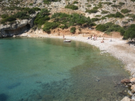
Beaches
Though there are no beaches as such on the island, you can take a little boat to the particularly beautiful blue grotto of Parasta, and there is excellent swimming from the rocks near the port. Boats are also on hand to take you to the nearby islets of Ro (6 n.mi. west) and Strongili (5 n.mi. southeast). Both islands have wonderful beaches. Ro became famous when its sole inhabitant, the lady of Ro, used to raise the Greek flag there every morning. 


Useful Information
How to get there
By sea from Piraeus
Piraeus Port Authority: +30 2104226000-4, +30 2104114005
By air from Athens
Olympic Airways: +30 2103550500

Useful telephone numbers Area Code: +30 22460
Municipality: 49232, 49269
Police: 49333
Port Authority: 49270
Olympic Airways: 49250
Health Center: 49267

http://www.megisti.gr

Sunday, September 4, 2011

Kasos (Kassos), Dodecanese Islands

In brief
Kasos (or Kassos) is a small island, very close to both Crete and Karpathos. In the summer, the northeastern winds blow from Crete, while rain rarely falls in the winter. Due to the dry climate and the rocky terrain there are not a lot of cultivated areas, yet there are many sheep and goats producing top quality dairy products. The island has a growing tourist business, and the people are always willing to be hospitable and helpful to anybody who decides to visit the island.

General Information
Kasos, the most southern of the Dodecanese, is only 27 nautical miles northeast of Crete. Its first inhabitants are thought to have been the Phoenicians. Homer mentions it in his catalogue of the Greek cities that took part in the Trojan War. Kasos is a mountainous island with a steep, rocky coastline and few beaches. In the 18th century, Kasos established its own merchant fleet and grew rich from trade. It played an active role in the Greek War of Independence of 1821, earning the revenge of the Turkish-Egyptian armada, which set fire to the island in May 1824 and subsequently slaughtered its inhabitants. Only a few survived.

The capital of the island is Fri, built on picturesque Bouka Bay. Its old stone houses – many of them constructed by sea captains – extend on both sides down to the sea.
To the east and very near Fri is Emborios, the island’s other coastal village. It boasts a beautiful church dedicated to the Nativity of the Virgin.
Other villages include Agia Marina, set on a hill just one kilometre southwest of Fri, and Arvanitohori, southeast of Agia Marina, nestled in the island’s only valley.
Two kilometres from Agia Marina there is a cave called Sellai, 30 metres deep and 8 metres wide, with impressive stalactites.

Sightseeing
Fri is the capital of the island and is very picturesque with its stone houses. There is a church worth visiting here called Agios Spyridonas.
Emborios is another pretty village, with a church dedicated to the Virgin Mary.
In Ellinokamara there are caves where archeologists have found traces of Neolithic settlements. Sellai is a stalactite cave you can visit.
In Poli, the old capital, there are some remains of the Venetian Kastro, and a beautiful church, Agia Triada.

Beaches
Swimmers will find pleasant beaches at Fri, Emborios, Ammouda, Antiperatos  and on the nearby islet of Armathia. 


Useful Information
How to get there
By air from Athens
Olympic Airways: +30 2103550500
By sea from Piraeus
Piraeus Port Authority: +30 2104226000-4, +30 2104114005

Useful telephone numbers
Area Code: +30 22450
Municipal Office: 41277
Police: 41222
Port Authority: 41288
Health Center: 41333

Kalymnos, Dodecanese Islands

In brief
Sponge-fishers & fishermen island. The main port of Pothia is lined with cafes and as home to Greece's sponge fishing fleet is a working town. There is a sponge museum there too. There are resort beaches around the island and several other small ports and towns worth visiting. It is also a popular island for rock climbing.

General Information
The terrain of this fourth largest of the Dodecanese is mountainous, except for two fertile valleys. It is along these valleys that its biggest villages have sprouted – Kalymnos or Pothia and Vathi.
Castles, remnants of fortresses, archeological findings, and old churches bear witness to the continuous importance of Kalymnos in the history of the Aegean. Its natural attractions – caves, lovely beaches, unspoilt scenery – make it a mini earthly paradise.
Kalymnos is widely known as the sponge-fishers’ island, since such a large portion of the population is engaged in this age-old occupation.
Once the island’s capital was located at Horio, which benefited from the protection offered by the castle of the Knights of St. John just above it.
Today’s capital is Pothia or Kalymnos, founded around 1850 by the inhabitants of Horio.

Its brightly coloured houses surround the port like the seats in an amphitheatre, arranged along the hillsides down to the caiques and fishing boats bobbing below. An old church dedicated to Christ the Saviour adorns the waterfront. It is decorated with frescoes and valuable icons, while its iconostasis is the work of the well-known sculptor, Yiannoulis Halepas.
Kalymnos has other charming villages, like Vathi, set in a fertile valley full of citrus trees, and Metohi, on the southeast side of the island. The quiet hamlet of Emborios lies to the north. To the west you will find the villages Massouri, Mirties, Kamari and Panormos.

On the road to Panormos, you will notice the remains of a three-aisled basilica dedicated to Christ of Jerusalem, which was erected around the 6th century on the site of an ancient temple where Delian Apollo was worshipped.
To the north of the main town is Perl Kastro, also called the Castle of the Golden Hands (Hrissohera), because the chapel in its interior has an icon of the Virgin whose hands are covered with gold leaf. Northeast of Pothia, at the foot of Flaska hill, is the cave of the Seven Virgins or Nymphs (not to be visited).

Kalymnos boasts two other caves, the richly decorated Skalies, about 100 metres from the village of Skalia in the north of the island (not to be visited), and Kefalas or Trypas Kefalas to the south (which can be visited and can only be approached by boat).
At Therma, only 1 km or so from Pothia, there are radioactive springs and therapeutic bathing installations, rooms where visitors may spend the night, and specially trained personnel to assist them.

Sightseeing 
In the island's capital Pothia (Kalymnos) you'll find a nice museum about the island. There is also a beautiful church here dedicated to Christ. There is also a nunnery, Agios Savas, which is open to the public and is well worth a visit.  There are also several sponge factories you can visit. 
Horio is the old capital, and here you can visit the Castle of Golden Hands (Kastro Hrissoheras) where the Knights of St. John resided. There is also a citadel from the 9th cent. AD, Pera Kastro, and the remains of a church from the 5th century: "Jesus of Jerusalem".

Beaches
Among the lovely beaches on Kalymnos are Massouri, Mirties and Arginondas along the west coast and Vlyhadia in the south.

Things to taste & buy 
You should taste seafood delicacies such as “fouskes” and “chtapokeftedes” (octopus fried meatballs).
You should buy natural sponges.


Useful Information
How to get there
By air from Athens 
Olympic Airways: +30 2103550500
By sea from Piraeus
Piraeus Port Authority: +30 2104226000-4, +30 2104114005

Useful telephone numbers
Area Code: +30 22430
Municipal Office: 59141
Police: 22100
Port Authority: 29304, 24444
Olympic Airways: 59370 (airport)
Health Center: 23025

Halki (Chalki), Dodecanese Islands

In brief
Halki (or Chalki), once sponge-fishing center with a rich fleet and thousands of people living there, took its name from the copper (chalkos or halkos in Greek), that mined in antiquity. A small, quiet and unspoiled island with an attractive village port and few people. It is a place for those who love walking, which in fact are rewarding.

General Information
Situated to the south of Tilos and west of Rhodes, Halki has been inhabited since antiquity, when it must have been very prosperous, judging from the coins found by archaeologists.
Its name most probably reflects the copper ore (chalkos or halkos in Greek) once mined there.
It is a small but mountainous island, just 28 sq. km in area.
The island capital and port is called Halki or Nimborio. Situated on the southeast coast, its two-stored houses with their tile roofs seem to climb up the sides of the hill overlooking the bay of the same name. The church of Agios Nikolaos, built in 1861, whose magnificent bell tower soars above the surrounding houses is worth a visit.
In earlier times, the capital was at Horio, which was placed well inland in an effort to escape the frequent pirate raids that were once the scourge of the Aegean. At its peak, it boasted 4,000 inhabitants; nowadays it is virtually deserted. Its stone houses, built in tiers like an amphitheatre, are mute reminders of its past prosperity. Above Horio the ruined medieval castle occupies the site of the ancient acropolis. Within its walls is another church dedicated to St. Nicholas (Agios Nikolaos) with frescoes.

Sightseeing  
Halki or Nimporio, the amphitheatrically built capital, a picturesque village worth scrolling around.
The Belfry of St. Nicholas. Horio with its medieval castle and the monastery of the Holy Cross; its feast is on the 14th of September. 
Halki has often praised in love-songs and its coins show that it was highly civilised in Antiquity.
Highlight this!
In 1983 Halki was declared an Island of Peace and Friendship of Young People of All Nations. On this occasion the Under-Secretariat of State of Youth and Sport, in co-operation with UNESCO, founded in the island an International Centre of friendship and co-operation among the young people of the world.

Beaches
Pondamos is the only beach in Halki accessible on foot from Nimborio (10 min.), but caiques are on hand to take you to its other wonderful beaches: Trachia, Ftenagia, Sarri, Kania, Areta and Yialli (Giali).


Useful Information
How to get there
By sea from Piraeus
Piraeus Port Authority: +30 2104226000-4, +30 2104114005
Useful telephone numbers
Area Code: + 30 22460
Municipal Office: 45207 
Police: 45213 
Port Authority: 45220
Health Center: 45206

Saturday, September 3, 2011

Agathonisi, Dodecanese Islands

In brief
This is one of those almost untouched islands by time and tourism, and here, you'll find Greece at its most genuine and traditional. A tiny island, Agathonisi is quiet and peaceful with only donkeys and roosters to wake you up in the morning, since it is almost traffic free.

General Information
The easiest jaunt to Agathonisi is from Patmos. This islet with its wonderful beaches is an ideal spot for anyone wishing to escape the pressures of everyday life for a while. In older times it was called Netousa or Tragea. The islanders live mainly off fishing and the tourists that visit the island every summer. The locals have often gone through hardships because of poverty and isolation, but they are warm and friendly and will try to make you feel at home as soon as you arrive.
Here the visitor's glance cannot stay cool; one experiences a never-ending wandering adventure.
There are three communities in Agathonisi: Mikro Chorio, Megalo Chorio and Agios Georgios. Megalo Chorio is the largest and oldest community on the island where most islanders live, while the other two communities Mikro Chorio and Agios Georgios – the island’s main harbour – have only few inhabitants each.

Sightseeing 
The island doesn't have any special sights apart from a couple of small churches. There are also archeological remains dating from the Hellenistic & early Roman period, found on the island's north side where the ancient city - harbour Tragea used to be. 

Beaches
Agathonisi has many beaches, pebbled with clear blue waters: Ai Giorgis, Spilia, Gaidouravlako, Tsaggari, Palos, Poros, Vathi Pigadi, Chohlia and Katholiko and few others.


Useful Information
How to get there
By sea from PIreaus
Piraeus Port Authority: +30 2104226000-4, +30 2104114005

Useful telephone numbers
Area Code: +30 22470
Municipal Office: 29009, 29010
Police: 29029
Port Authority: 31231
Health Center: 29049

http://www.agathonisi.gr

Thursday, September 1, 2011

Astypalea, Dodecanese Islands

In brief
Astypalea (or Astypalaia), with its whitewashed sugar cube house, narrow alleys and windmills, has a more Cycladic character than Dodecanesean where it belongs. Astypalea is a butterfly-shaped island; a narrow isthmus a mere 100 meters wide connecting its two wings, with citrus groves and decent mountainous walking country.

General Information
This most western of the Dodecannese has had many names: Ichthyoessa (abundant in fish) in ancient times; Stampalia or Astropalia, as the locals call it today. The name Astipalea means “old city”.
A mountainous island with an indented coastline concealing numerous delightful coves, Astipalea in fact resembles two islands joined by a ribbon of land only 100 metres wide.
The main village is Hora or Astypalea, built up the side of a steep hill, and presided over by the massive, austere remains of a Venetian castle. Its small,
square houses, painted white with brightly coloured doors and windows, follow the contours of the hill in an almost unbroken band down to the sea. So closely are they packed, that the walls of the uppermost houses form part of the outer fortifications of the castle. According to tradition, Kleomedes -an Olympian boxer- was the island's most famous citizen in antiquity, as he killed in the 71st Olympiad a competitor with a foul blow. He came home so enraged that he demolished the local school, killing all its pupils.
A row of windmills on the pass of the hill provides an additional picturesque
note. One enters the castle from the southwest side of the hill. Inside it are two churches, dedicated to St. George and to the Annunciation (Evangelismos). The former contains a noteworthy carved iconostasis.
Below the castle stands the 18th century church of Our Lady Portaitissa, one of the most beautiful in the Dodecanese. It too has an impressive iconostasis, covered with gold leaf.
Livadia, Analipsi and Vathi are charming fishing hamlets on the south and north coast of the island.

Sightseeing 
In Hora there is a small archeological museum, a few interesting churches and a citadel. The remains of a Roman Villa are to be seen in the village Maltezana (Analipsis). Here, there is also a monument over the perished crew of the French ship Bison that sunk in 1827. In Vathi you can visit the Cave of the Dragon, Dracospilia.

Beaches
Beautiful beaches can be found all around the island for visitors to enjoy. Pera
Yialos, Livadi (with sand and pebbles), Tzanaki, Moura, Pappou and Agios
Konstantinos are some of them while there are more remote beaches at Vatses, Kaminakia, Panormos and Agios Ioannis and Pachia Ammos (accessible by boat).
Moreover, there are also outstanding beaches at Marmari, Schinondas, Karekli, Vrysi, Plakes (a rocky beach), Steno and Psili Ammos.


Useful Information
How to get there
By air from Athens
Olympic Airways: +30 2103550500 
By sea from Pireaus
Piraeus Port Authority: +30 2104226000-4, +30 2104114005

Useful telephone numbers
Area Code: +30 22430
Municipality: 61217, 61206
Police: 61207
Port Authority: 61208
Olympic Airways: 61410, 61665 (airport), 61588 (tickets)
Health Center: 61222

http://www.astypalaia.gr